
 Equatorial Margin
A seismic survey and the interpretation of geological and geophysical data from the sedimentary basins of the Equatorial Margin, conducted by Petrobras geologists and geophysicists, supported the UN’s decision on Brazil’s continental shelf claim.
T&B Petroleum/Petrobras Agency
A comprehensive geological and geophysical data acquisition and interpretation effort along Brazil’s entire continental margin, conducted by Petrobras professionals over decades, has led to a major diplomatic and economic achievement for the country: the expansion of Brazil’s continental shelf beyond the 200-nautical-mile limit in the North region, in accordance with the United Nations Convention on the Law of the Sea (UNCLOS). Previously, Brazil’s outer limit was 200 nautical miles, the standard for any coastal state under UNCLOS.
With the UN’s publication of the Summary of Recommendations from the Commission on the Limits of the Continental Shelf (CLCS) regarding Brazil’s Revised Partial Submission for the Equatorial Margin, Brazil’s sovereign rights over an additional 360,000 square kilometers of maritime territory have been recognized. This area is roughly equivalent to the size of Germany. The decision grants Brazil the right to explore natural resources on the seabed and subsoil of this newly recognized maritime region.
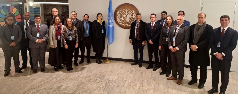
“For Petrobras, it is an immense satisfaction and honor to have researchers who worked alongside the Brazilian Navy in this process with the UN. We understand the significance of this expansion for Brazil—not only does it strengthen national sovereignty, but it also allows access to the resources present in the region. Petrobras and the Brazilian Navy have had a long-standing partnership, and this is yet another historic outcome of our joint efforts,” said Sylvia Anjos, Petrobras’ Director of Exploration and Production.
UNCLOS allows countries to extend their maritime limits beyond 200 nautical miles, provided they submit scientific and technical studies demonstrating the extension of their continental shelf, in accordance with the Convention’s criteria. The technical process involves determining the natural prolongation of the submerged continental mass, based on seabed geomorphological parameters and sediment thickness.
These studies supported the work of the Leplac Project (Brazilian Continental Shelf Survey), conducted by Navy professionals with the participation of dozens of Petrobras technicians. These experts contributed to the acquisition, processing, interpretation, and integration of geophysical, geological, and geochemical data along Brazil’s entire continental margin, particularly the Equatorial Margin. The findings were compiled into technical reports and peer-reviewed scientific articles published in international conferences and journals. The CLCS rigorously evaluated these studies over an extensive review process to ensure compliance with the UN’s technical requirements.
These geological characteristics served as the foundation for determining Brazil’s expanded continental shelf boundaries along the Equatorial Margin.
This initiative dates back to the 1980s, when Brazil signed UNCLOS, commonly known as the "Law of the Sea." In response, the Brazilian government created the Continental Shelf Survey Plan (LEPLAC), coordinated by the Interministerial Commission for Marine Resources, led by the Brazilian Navy.
In 1987, Petrobras’ geologists and geophysicists began a comprehensive survey of Brazil’s entire continental margin, involving the acquisition, processing, and interpretation of geophysical and geological data. This required advanced computing capabilities and specialized technical expertise. The insights gained from these efforts, combined with LEPLAC’s meticulous work, enabled Brazil to define the new limits of its continental shelf in accordance with UNCLOS criteria.
Since the 1994 entry into force of the United Nations Convention on the Law of the Sea (UNCLOS), Brazil began developing its “proposal for the outer limits of the Brazilian continental shelf” to be submitted to the Commission on the Limits of the Continental Shelf (CLCS). Since then, Petrobras has actively participated in the development of this proposal, either through geophysical data acquisition and processing across the entire Brazilian continental margin or by participating in working groups tasked with submitting proposals to the UN. The subsoil and seabed of this area can be explored for all its natural resources, which represents a legacy for future generations of Brazilians.


Contact us