
T&B Petroleum/Press Office TGS

With the aim of strengthening navigational safety and protecting maritime communities, TGS, a leading geoscience data acquisition company, has developed the Notice to Mariners application. The tool enables real-time monitoring of vessels involved in seismic survey activities in the Pelotas Basin, located approximately 100 km offshore between the states of Santa Catarina and Rio Grande do Sul.
The application provides detailed information on the exact location of the vessels Ramform Titan and Ramform Tethys, which operate in the northern and southern portions of the basin, respectively. The initiative seeks to prevent incidents in an area characterized by intense maritime traffic and fishing activities.
The need for the tool arises from the technical characteristics of the operation. Because they tow extensive arrays of sensitive equipment, survey vessels have limited maneuverability.
“It is essential to maintain a safe distance from these vessels. We have established a safety zone of at least 6 nautical miles ahead of the vessel, 3 miles on each side, and 2 miles around the tail buoys located at the stern,” explains José Luis Pizzorno, the oceanographer responsible for TGS’s environmental strategies for the project.
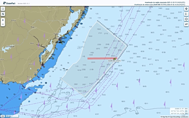
To ensure compliance with these distances, TGS maintains support and standby vessels permanently positioned around the main vessels, guiding other mariners approaching the area.
In addition to the new application, official communication continues to be carried out daily via the Itajaí Coastal Radio Station and through the Brazilian Navy’s Notice to Mariners bulletins.
The application is free of charge and can be accessed in two ways: by downloading it from the official website margemsulbrasil.com.br or via direct web access at avisoaosnavegantes.oceanpact.app.


Contact us